このブログを検索

大文字小文字を区別する 正規表現

Atelierで“Lightbox2.51”が含まれるブログ記事

2014年11月 3日

隠居のスマホ備忘録:山旅ロガーを使う。(2)測定結果を Google Map に表示する


 前回、スマホのアプリ山旅ロガーを使う方法について記録した。
 このトラッキング測定結果は、GPX というファイルとKML という形式のファイルでPC に送信することができる。GPX ファイルについては、ネットにあまり自分がやりたいことにぴったり来る情報がない。KMLファイルは、XML ファイルの一種のようなので、多少馴染みがあるので、こちらでトライしてみることにした。
 PC への送信方法は、メールにファイルを添付する方法と Bluetooh で送信する方法がある。PC の近くでの作業では、どちらをとっても大差はない。
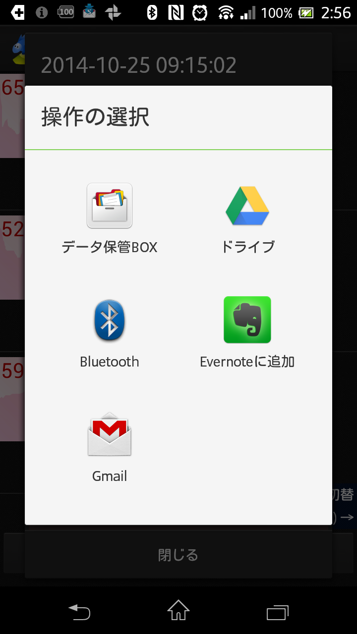
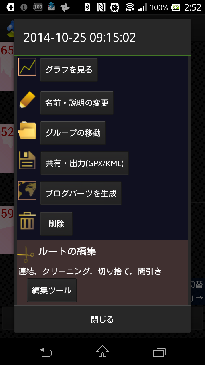
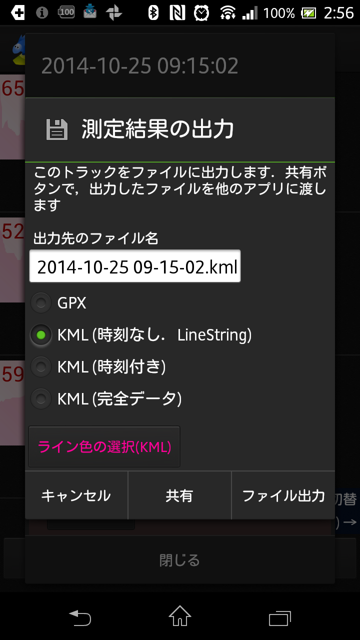
測定結果をPCに送信する
測定結果ファイルの機能ボタンをタップすると 左の画面で「共有・出力」ボタンをタップすると;クリックすると大きな写真になります。 ファイル送信方法の選択画面;クリックすると大きな写真になります。"
測定結果一覧で該当ファイルの機能ボタンをタップすると、上のような画面になる。 左の画面で「共有・出力」ボタンをタップすると右の画面になる。 上の画面で Gmail または Bluetooth を選択して、指示に従いPC に送信する。


上の真ん中のスクリーンショットにあるように、KMLファイルを出力するときには、3つの形式から選択できる。
  • ①トラッキングしたルート(ライン)のみを表示する。
  • ② ①に時刻をつける
  • ③ 測定地点にマーカーを立て、時刻と text を表示する

 このような KMLファイルをPC に取り込んで、Google Maps API 表示するサンプルを見つけた。
 このサンプルコードを参考に、自宅から栂・美木多駅までの測定結果の ② の形式KMLファイルを取り込んだHTMLページを作成すると次のように表示された。


 上の地図は、Google Map の機能を持っているので、ストリートビューが見られるなど、駅から自宅までの道案内に有用かもしれない。

 同じトラッキングデータを上の ③ の形式で取り込んで、上のサンプルコードの kml アドレスを変更して Google Map に表示してみると、測定地点のマーカが連なって表示される。
 この時のKMLファイルの中身を覗く方法がわからなかったが、KMLがXMLファイルの一種であることにヒントを得て、XML notepadで開いてみると、これで編集できることが分かった。(もちろん、秀丸のようなテキスト・エディタでもできる)
 だが、固有のタグについては、かなりの学習が必要なようだ。とりあえず、分かりそうなタグに見当をつけて、試行錯誤を繰り返して見た。

 そのようにして作ってみた地図を下に表示する。


  この地図では、もともと38個あったマーカーを間引きして9個にし、
  • 地点1を"自宅"の文字に置き換え、
  • 駅への通り道にある風邪を引いた時などにお世話になる清水内科近く(15の地点)にはGoogle サーチの結果リンクを、
  • 24の地点(池のそば)のマーカ(24の地点)には、その地点で撮った水鳥の写真を表示するリンクを、
  • 終点の栂・美木多駅には、泉北高速鉄道のサイトで表示される栂・美木多駅ページヘのリンク
を挿入してみた。
  写真表示には、撮った写真をかっこ良く表示させる、Google Maps API を使って地図を作成する時に使っている、lightbox のコードを追加してみると上手く動いてくれた。

 上の地図のためのコードは、以下である。

<!DOCTYPE html PUBLIC \"-//W3C//DTD XHTML 1.0 Strict//EN\" \"http://www.w3.org/TR/xhtml1/DTD/xhtml1-strict.dtd\">
<html xmlns=\"http://www.w3.org/1999/xhtml\" xmlns:v=\"urn:schemas-microsoft-com:vml\">
<head> 
<meta name=\"viewport\" content=\"initial-scale=1.0, user-scalable=no\" />

<!-- jQuery lightbox2.51 -->
<script type=\"text/javascript\" src=\"http://n-shuhei.net/atelier/Jquery2.51/js/jquery-1.7.2.min.js\"></script>
<script type=\"text/javascript\" src=\"http://n-shuhei.net/atelier/Jquery2.51/js/lightbox.js\"></script>
<link rel=\"stylesheet\" type=\"text/css\" href=\"http://n-shuhei.net/atelier/Jquery2.51/css/lightbox.css\" media=\"screen\" />

<script type=\"text/javascript\" src=\"http://maps.googleapis.com/maps/api/js?sensor=false&hl=ja\"></script>
<script type=\"text/javascript\">
  function initialize() {
    var initPos = new google.maps.LatLng(34.490435, 135.482852);
    var myOptions = {
      noClear : true,
      center : initPos,
      zoom : 15,
      mapTypeId : google.maps.MapTypeId.ROADMAP
    };
    var map_canvas = new google.maps.Map(document.getElementById(\"map_canvas\"), myOptions);
    
    var kmlUrl = \"http://n-shuhei.net/atelier/maps/KML-test/141025P.kml\";
    var kmlLayer = new google.maps.KmlLayer(kmlUrl);
    kmlLayer.setMap(map_canvas);
  }

</script>
  </head>

<body onload=\"initialize()\">
  <div id=\"map_canvas\" style=\"width:100%; height:500px\"></div>
</body>
</html>


 ここで、指定しているKMLファイルは、テキストコードは以下である。実際の編集は、XML notepad で作業している。


<?xml version=\"1.0\" encoding=\"utf-8\"?>
<kml xmlns=\"http://www.opengis.net/kml/2.2\">
  <Document>
    <name><![CDATA[2014-10-25 09:15:02]]></name>
    <description><![CDATA[自宅ー駅:2014-10-25 09:15~2014-10-25 09:33]]></description>
    <Placemark>
      <name>自宅</name>
      <description>2014-10-25 09:15:02:</description>
      <TimeStamp>
        <when>2014-10-25T00:15:02.000Z</when>
      </TimeStamp>
      <Point>
        <coordinates>135.48277,34.490517,30</coordinates>
      </Point>
    </Placemark>
    <Placemark>
      <name>5</name>
      <description>2014-10-25 09:16:44</description>
      <TimeStamp>
        <when>2014-10-25T00:16:44.000Z</when>
      </TimeStamp>
      <Point>
        <coordinates>135.48332,34.49017,37</coordinates>
      </Point>
    </Placemark>
    <Placemark>
      <name>10</name>
      <description>2014-10-25 09:18:55</description>
      <TimeStamp>
        <when>2014-10-25T00:18:55.000Z</when>
      </TimeStamp>
      <Point>
        <coordinates>135.48485,34.489635,33</coordinates>
      </Point>
    </Placemark>
    <Placemark>
      <name>15</name>
      <description><![CDATA[<a href=\"https://plus.google.com/104149416183172006475/about?gl=jp&hl=ja\">清水内科</a>]]></description>
      <TimeStamp>
        <when>2014-10-25T00:21:05.000Z</when>
      </TimeStamp>
      <Point>
        <coordinates>135.48608,34.488583,45</coordinates>
      </Point>
    </Placemark>
    <Placemark>
      <name>20</name>
      <description>2014-10-25 09:23:15</description>
      <TimeStamp>
        <when>2014-10-25T00:23:15.000Z</when>
      </TimeStamp>
      <Point>
        <coordinates>135.48712,34.487377,48</coordinates>
      </Point>
    </Placemark>
    <Placemark>
      <name>24</name>
      <description><![CDATA[<a href=\"http://n-shuhei.net/atelier/photo_birds/DSC04864.JPG\" title=\"\" rel=\"lightbox[]\">マガモ交雑種</a>]]></description>
      <TimeStamp>
        <when>2014-10-25T00:25:00.000Z</when>
      </TimeStamp>
      <Point>
        <coordinates>135.48792,34.486824,46</coordinates>
      </Point>
    </Placemark>
    <Placemark>
      <name>29</name>
      <description>2014-10-25 09:27:12</description>
      <TimeStamp>
        <when>2014-10-25T00:27:12.000Z</when>
      </TimeStamp>
      <Point>
        <coordinates>135.48877,34.48632,54</coordinates>
      </Point>
    </Placemark>
    <Placemark>
      <name>35</name>
      <description>2014-10-25 09:30:48</description>
      <TimeStamp>
        <when>2014-10-25T00:30:48.000Z</when>
      </TimeStamp>
      <Point>
        <coordinates>135.49054,34.485283,53</coordinates>
      </Point>
    </Placemark>
    <Placemark>
      <name>38</name>
      <description><![CDATA[<a href=\"http://www.semboku.jp/station/toga_mikita/outline/\">栂・美木多駅</a>]]></description>
      <TimeStamp>
        <when>2014-10-25T00:33:30.000Z</when>
      </TimeStamp>
      <Point>
        <coordinates>135.48999,34.484875,61</coordinates>
      </Point>
    </Placemark>
  </Document>
</kml>


 もう少し高度な加工ができそうであるが、一段の学習が必要のようだ。痴呆予防には役立つかもしれないので、もうちょっと遊んでみたいと思っている。

2013年2月 3日

隠居のブログ備忘録:JQuery lightbox 2.51 をカストマイズする

 
 昨年夏に、サムネイル写真をクリックするとウインドウ中央に写真が拡大表示される Llightbox を jQuery という JavaScript のライブラリーを使用した Lightbox2.51 を導入した。
 その時、カストマイズしたのは、デフォールトでは黒である背景画面の色を緑にしたのと、写真ページを閉じるボタンを デフォールトのclose.png から、自作の closelabel.gif に変更しただけである。

 私が管理している友人の Lightbox は、prototype.js という JavaScript のライブラリーを使った旧バージョン Lightbox2.0 を使っている。背景画面に、蝶をあしらった壁紙を使っていて、これを Lightbox2.51 で使う方策が分からなかったからである。
  Lightbox2.51 のカストマイズは、【jQueryのlightBoxプラグインの使い方】【jQuery LightBox Pluginの使い方】 などに詳しい。これらのプラグインは、新たに JavaScript を付け加えてカストマイズする方法である。だが、私のやり方が悪かったのか上手く行かなかった。
 そこで、当初導入した時にいじったJavaScript lightbox.js と スタイルシート lightbox.css 再度いじって見ることにした。 私にコードが理解できるわけではないから、やりかたは ここはと思われるスクリプト ないしは CSS をいじって、FTP でサーバーにアップロードし、実際のページでの変化を観察する方法である。幸い、JavaScript と CSS の変更は、すぐにページに現れるから楽である。この結果を備忘録として記録しておきたいと思う。

  1. 自作の closelabel に置き換える。
    lightbox.js の41行目を下のように独自の画像に置き換える。
          this.fileCloseImage = 'http://n-shuhei.net/atelier/Jquery2.51/images/closelabel.gif';

  2. セットで写真を表示している場合の表示を "image"(default) から "画像"に置き換える。44行目
          this.labelImage = " 画像 "; 

  3. セットの写真の何枚目を示す、表示を例えば "1 of 8" を " 1 / 8 "に置き換える。45行目
          this.labelOf = "/";  

  4. 背景画面を単一色から、壁紙画面に変える。lightbox.ccs の7行目あたりの背景色をコメントアウトして、壁紙イメージを挿入する。
    /*  background-color: #000000; */
    background-image: url("http://n-shuhei.net/atelier/lightbox2/images/overlay_1.jpg") ; 

  5. 画像の枠(台紙)の色をかえる。lightbox.ccs の35行目あたり。デフォールトは、"white;"
       background-color: #ffffe0;

  6. 画面の"前画面" "次画面" へのボタンを独自のボタンに置き換える。lightbox.ccs の112行目、117行目あたり。 
        background: url(http://n-shuhei.net/lightbox2/images/prevlabel.gif) left 40% no-repeat;

    background: url(http://n-shuhei.net/lightbox2/images/nextlabel.gif) right 40% no-repeat;

  7. 写真の説明文字の色を変える。lightbox.ccs の145行目あたり。デフォールトは灰色。
     color: #ffffff;

 その他、細かい部分も、CSS をいじることで変えられそうだ。
サンプル画像は、次のエントリー【隠居の探鳥ウォーク:ハリエンジュ 花芽ついばむ 鷽(ウソ)4羽 】などで確認できます。


2012年9月22日

隠居のパソコン備忘録: Google Maps API JS V3 で、番号付きマーカーを表示する

 
 従来、右フレームの【晩秋の宍道湖私的観光地図】は、Google Maps API のV2版で作成したものを置いていた。V2 でかいた地図はまだ動くが、2010年5月に廃止されており、V3 へ移行することが奬められている。
 この地図では、必要性はあまりないが、マーカーに番号を表示させていた。新しく V3 で作りなおすときにも、学習も兼ねて番号を表示させたかった。

 ところが、番号入りマーカーを表示するサンプルコードが見つからない。V2 で作成したコードを V3 に置き換えることも試みたが、悲しいかな十分な知識がないし、一から勉強する意欲もないので、うまく行きそうにない。
 今までに成功した V3 のコードを眺めていると【Google Maps API JS V3 で、カテゴリー別に色違いマーカーを表示する】 で使ったコードを、わかる範囲でいじってみれば、なんとかなるのではないかと思われた。色違いのマーカーを、番号付きマーカーに置き換えるのである。この地図では、category 別に赤・青・黄色・緑などのマーカーにしているが、これを番号つきのマーカーに置き換えるのである。また、また、一つずつのマークを、一つのカテゴリーと考えるのである。
 このコードでは、マーカーを立てる地点の経度・緯度や吹きだしに表示するHTMLなどは、XML ファイルを読み込んでくることになっている。V2 で作成した地図では、HTMLの中に直接入力されていた。

 とりあえずうまく表示できるようなので、自分用の備忘録として、XML ファイルおよびHTML コードを記録しておきたい。よくわかった人から見れば、へんてこなコードとなっていると思うが、古希を超えるとほとんど羞恥心はなくなっている。

使用したXML ファイル。項目 category は num01, num02・・・のようになっている。
<?xml version="1.0" encoding="utf-8" ?> 
- <markers>
  <marker name="1:宍道湖温泉" address="   <a href="http://n-shuhei.net/atelier/photo_drive/DSC_4820-1.JPG" title="宍道湖の夕焼け" rel="lightbox[sinjiko]">宍道湖の夕焼け</a><br/>   <a href="http://n-shuhei.net/atelier/photo_drive/DSC_4831.JPG" title="宍道湖の朝" rel="lightbox[sinjiko]">宍道湖の朝</a>" lng="133.053875" lat="35.469199" category="num01" /> 
  <marker name="2:米子水鳥公園" address="   <a href="http://n-shuhei.net/atelier/photo_digisco/DSC01539.JPG" title="コハクチョウ" rel="lightbox[sinjiko]" >コハクチョウ</a><br/>   <a href="http://n-shuhei.net/atelier/photo_digisco/DSC01510.JPG" title="オナガガモ:♀を追いかける♂たち" rel="lightbox[sinjiko]" >オナガガモ</a><br/>   <a href="http://n-shuhei.net/atelier/photo_digisco/DSC01529.JPG" title="マガンの群れ:沖の州" rel="lightbox[sinjiko]" >マガンの群れ</a><br/>   <a href="http://n-shuhei.net/atelier/photo_digisco/DSC01591.JPG" title="キンクロハジロ?" rel="lightbox[sinjiko]" >キンクロハジロ</a>" lng="133.284674" lat="35.44333" category="num02" /> 
  <marker name="3:宍道湖グリーンパーク" address="   <a href="http://n-shuhei.net/atelier/video/digisco_1.wmv" target="_blank">コハクチョウ(video)</a><br/>   <a href="http://n-shuhei.net/atelier/photo_digisco/DSC01620.JPG" title="セグロセキレイ" rel="lightbox[sinjiko]" >セグロセキレイ</a><br/>   <a href="http://n-shuhei.net/atelier/photo_digisco/DSC01632.JPG" title="トビ?" rel="lightbox[sinjiko]" >トビ</a><br/>   <a href="http://n-shuhei.net/atelier/photo_birds/0911211.jpg" title="ジョウビダキ?" rel="lightbox[sinjiko]" >ジョウビダキ</a><br/>   <a href="http://n-shuhei.net/atelier/photo_drive/DSC_4872.JPG" title="ゴビウスにある水槽" rel="lightbox[sinjiko]">ゴビウスにある水槽</a>" lng="132.866077" lat="35.444729" category="num03" /> 
  <marker name="4:出雲大社" address="   <a href="http://n-shuhei.net/atelier/photo_drive/DSC_4886.JPG" title="出雲大社にて" rel="lightbox[sinjiko]">出雲大社にて</a>" lng="132.685919" lat="35.401434" category="num04" /> 
  <marker name="5:足立美術館" address="   <a href="http://n-shuhei.net/atelier/photo_drive/DSC_4908.JPG" title="足立美術館の紅葉" rel="lightbox[drive]">足立美術館の紅葉</a><br/>   <a href="http://n-shuhei.net/atelier/photo_drive/Stitched_003.JPG" title="枯山水の庭:3枚の合成写真" rel="lightbox[drive]">枯山水の庭</a><br/>   <a href="http://n-shuhei.net/atelier/DSC_4932.JPG" title="足立美術館:絵画を観ているように" rel="lightbox[drive]">仏間から庭を望む</a>" lng="133.198242" lat="35.377854" category="num05" /> 
  <marker name="6:米子自動車道大山PA" address="   <a href="http://n-shuhei.net/atelier/photo_drive/DSC_4720-1.JPG" title="雪化粧した大山:大山PAより" rel="lightbox[sinjiko]">大山の紅葉</a>" lng="133.419342" lat="35.386531" category="num06" /> 
  </markers>


 作成した地図作成の稚拙なHTMLコード(Google Maps API V3 のJavaScript を含む)は、右フレームに掲載している【晩秋の宍道湖私的観光地図】のソース・コードを見ていただければ、わかると思うが、参考までに下に記載し、少しのコメントを加えたいと思う。

<!DOCTYPE html PUBLIC "-//W3C//DTD XHTML 1.0 Strict//EN" "http://www.w3.org/TR/xhtml1/DTD/xhtml1-strict.dtd">
<html xmlns="http://www.w3.org/1999/xhtml" xmlns:v="urn:schemas-microsoft-com:vml">
<head> 
<meta name="viewport" content="initial-scale=1.0, user-scalable=no" /> 
<meta http-equiv="content-type" content="text/html; charset=UTF-8"/> 

<title>Google Maps Javascript API v3 Example: Marker Categories</title> 

<!-- jQuery lightbox2.51 -->
<script type="text/javascript" src="http://n-shuhei.net/atelier/Jquery2.51/js/jquery-1.7.2.min.js"></script>
<script type="text/javascript" src="http://n-shuhei.net/atelier/Jquery2.51/js/lightbox.js"></script>
<link rel="stylesheet" type="text/css" href="http://n-shuhei.net/atelier/Jquery2.51/css/lightbox.css" media="screen" />

<script type="text/javascript" src="http://maps.google.com/maps/api/js?sensor=false"></script> 
<script type="text/javascript" src="http://n-shuhei.net/atelier/maps/V3test/downloadxml.js"></script>
    <title>Google Maps</title>
<style type="text/css">
html, body { height: 100%; } 
</style>
    <script type="text/javascript">
    //<![CDATA[
      // this variable will collect the html which will eventually be placed in the side_bar 
      var side_bar_html = ""; 
      var gmarkers = [];
      var gicons = [];
      var map = null;
var infowindow = new google.maps.InfoWindow(
  { 
    size: new google.maps.Size(150,50)
  });

gicons["01"] = new google.maps.MarkerImage("http://n-shuhei.net/Googlemaps/Markers/marker_01.png",
      // This marker is 20 pixels wide by 34 pixels tall.
      new google.maps.Size(20, 34),
      // The origin for this image is 0,0.
      new google.maps.Point(0,0),
      // The anchor for this image is at 9,34.
      new google.maps.Point(9, 34));
  // Marker sizes are expressed as a Size of X,Y
  // where the origin of the image (0,0) is located
  // in the top left of the image.
  // Origins, anchor positions and coordinates of the marker
  // increase in the X direction to the right and in
  // the Y direction down.

  var iconImage = new google.maps.MarkerImage('http://n-shuhei.net/Googlemaps/Markers/marker_01.png',
      // This marker is 20 pixels wide by 34 pixels tall.
      new google.maps.Size(20, 34),
      // The origin for this image is 0,0.
      new google.maps.Point(0,0),
      // The anchor for this image is at 9,34.
      new google.maps.Point(9, 34));
  var iconShadow = new google.maps.MarkerImage('http://n-shuhei.net/atelier/maps/V3test/msmarker.shadow.png',
      // The shadow image is larger in the horizontal dimension
      // while the position and offset are the same as for the main image.
      new google.maps.Size(37, 34),
      new google.maps.Point(0,0),
      new google.maps.Point(9, 34));
 
function getMarkerImage(iconNum) {
   if ((typeof(iconNum)=="undefined") || (iconNum==null)) { 
      iconNum = "01"; 
   }
   if (!gicons[iconNum]) {
      gicons[iconNum] = new google.maps.MarkerImage("http://n-shuhei.net/Googlemaps/Markers/marker_"+ iconNum +".png",
      // This marker is 20 pixels wide by 34 pixels tall.
      new google.maps.Size(20, 34),
      // The origin for this image is 0,0.
      new google.maps.Point(0,0),
      // The anchor for this image is at 6,20.
      new google.maps.Point(9, 34));
   } 
   return gicons[iconNum];
}

function category2num(category) {
   var num = "01";       
   switch(category) {
     case "num01": num = "01";
                break;
     case "num02": num = "02";
                break;
     case "num03": num = "03";
                break;
     case "num04": num = "04";
                break;
     case "num05": num = "05";
                break;
     case "num06": num = "06";
                break;
     default:   num = "01";
                break;
   }

   return num;
}

      gicons["num01"] = getMarkerImage(category2num("num01"));
      gicons["num02"] = getMarkerImage(category2num("num02"));
      gicons["num03"] = getMarkerImage(category2num("num03"));
      gicons["num04"] = getMarkerImage(category2num("num04"));
      gicons["num05"] = getMarkerImage(category2num("num05"));
      gicons["num06"] = getMarkerImage(category2num("num06"));
      // A function to create the marker and set up the event window
function createMarker(latlng,name,html,category) {
    var contentString = html;
    var marker = new google.maps.Marker({
        position: latlng,
        icon: gicons[category],
        shadow: iconShadow,
        map: map,
        title: name,
        zIndex: Math.round(latlng.lat()*-100000)<<5
        });

        // === Store the category and name info as a marker properties ===
        marker.mycategory = category;                                 
        marker.myname = name;
        gmarkers.push(marker);

    google.maps.event.addListener(marker, 'click', function() {
        infowindow.setContent(contentString); 
        infowindow.open(map,marker);
        });
}

      // == shows all markers of a particular category, and ensures the checkbox is checked ==
      function show(category) {
        for (var i=0; i<gmarkers.length; i++) {
          if (gmarkers[i].mycategory == category) {
            gmarkers[i].setVisible(true);
          }
        }

        // == check the checkbox ==
        document.getElementById(category+"box").checked = true;
      }

      // == hides all markers of a particular category, and ensures the checkbox is cleared ==
      function hide(category) {
        for (var i=0; i<gmarkers.length; i++) {
          if (gmarkers[i].mycategory == category) {
            gmarkers[i].setVisible(false);
          }
        }

        // == clear the checkbox ==
        document.getElementById(category+"box").checked = false;
        // == close the info window, in case its open on a marker that we just hid
        infowindow.close();
      }

      // == a checkbox has been clicked ==
      function boxclick(box,category) {
        if (box.checked) {
          show(category);
        } else {
          hide(category);
        }

        // == rebuild the side bar
        makeSidebar();
      }

      function myclick(i) {
        google.maps.event.trigger(gmarkers[i],"click");
      }

      // == rebuilds the sidebar to match the markers currently displayed ==
      function makeSidebar() {
        var html = "";
        for (var i=0; i<gmarkers.length; i++) {
          if (gmarkers[i].getVisible()) {
            html += '<a href="javascript:myclick(' + i + ')">' + gmarkers[i].myname + '<\/a>' + ' ' ;
          }
        }

        document.getElementById("side_bar").innerHTML = html;
      }

  function initialize() {
    var myOptions = {
      zoom: 10,
      center: new google.maps.LatLng(35.430603,133.012136),   //松江
      mapTypeId: google.maps.MapTypeId.HYBRID
    }
    map = new google.maps.Map(document.getElementById("map"), myOptions);
    google.maps.event.addListener(map, 'click', function() {
        infowindow.close();
        });

      // Read the data
      downloadUrl("http://n-shuhei.net/atelier/maps/V3_sinnjiko_num.xml", function(doc) {
  var xml = xmlParse(doc);
  var markers = xml.documentElement.getElementsByTagName("marker");
        for (var i = 0; i < markers.length; i++) {
          // obtain the attribues of each marker
          var lat = parseFloat(markers[i].getAttribute("lat"));
          var lng = parseFloat(markers[i].getAttribute("lng"));
          var point = new google.maps.LatLng(lat,lng);
          var address = markers[i].getAttribute("address");
          var name = markers[i].getAttribute("name");
          var html = "<b>"+name+"<\/b><p>"+address;
          var category = markers[i].getAttribute("category");
          // create the marker
          var marker = createMarker(point,name,html,category);
        }

        // == create the initial sidebar ==
        makeSidebar();
      });
    }

    //]]>
    </script>
  </head>

<body style="margin:0px; padding:0px;" onload="initialize()"> 
    <!-- you can use tables or divs for the overall layout -->
    <table border=1 >
<tr><td align="center"style="width:1000px; background-color: #ffffe0;" ><br /><h2>晩秋の宍道湖私的観光地図</h2></td></tr>      
<tr><td>
           <div id="map" style="width: 1000px; height: 500px"></div>
        </td></tr><tr>
<td valign="top" style="width:1000px; background-color: #ffffe0; font-size: small;"> 
 上の地図は、Google Mapsの機能を持っています。拡大・縮小・移動ができます。下の該当番号をクリックすると該当番号マーカーに吹きだしが出てきます。その吹き出しにある青文字をクリックすると写真(一部 動画)がでてきます。</td></tr><tr>
        <td valign="top" style="width:1000px; background-color: #ffffe0; font-size: small;"> 
           <div id="side_bar"></div>
        </td>
      </tr>
    </table>


    <noscript><b>JavaScript must be enabled in order for you to use Google Maps.</b> 
      However, it seems JavaScript is either disabled or not supported by your browser. 
      To view Google Maps, enable JavaScript by changing your browser options, and then 
      try again.
    </noscript>

<br /><br />
<!-- Google AdSense -->
<script type="text/javascript"><!--
google_ad_client = "pub-8556873278052332";
/* AdSense foot ad */
google_ad_slot = "1589991765";
google_ad_width = 728;
google_ad_height = 15;
//-->
</script>
<script type="text/javascript"
src="http://pagead2.googlesyndication.com/pagead/show_ads.js">
</script>
  </body>
</html>


  • 番号付きマーカーは、dLINKbRING というサイトからダウンロードできる
  • 表示する地図を、ラベル付き航空写真とするには、mapTypeId: google.maps.MapTypeId.HYBRID とすればよい。通常は、HYBRID の部分が、ROADMAP となっている。
  • マーカーをクリックしてでる吹きだしの中に表示される写真リンクをクリックして出てくる写真を、同一画面の中央に表示するJavaScript ソフト lightbox は機能する。 jQuerylightbox2.51 を使った。


2012年7月17日

隠居のパソコン備忘録: jQuery lightbox (同一画面上に拡大写真をかっこよく表示する)を導入する


 先日来、個人的地図作成サービス Google Maps API V3 を学習してきた。このサービスを使って、加賀地方旅行地図を作成したことを記録している。このサービスを学習中に、jQuery という JavaScript のライブラリーが、いろいろな JavaScript ソフトを導入するときに使われていることが分かった。

 この JavaScript ライブラリーの jQuery を使って、拡大写真の表示を同一画面上に表示する JavaScript の lightbox が新しいバージョン(Version 2.51)になっていることも分かった。(従来のライブラリーは、prototype.js )
 これを、先の加賀地方旅行地図での写真表示に使って見ることにした。
サンプル画像

 インストールについては、Lightbox2 のページから、Lightboxv2.51 をダウンロードし、PC のどこかのフォルダ(例えば、lightbox2.51 を作成し )に解凍する。
  上のページの【How to use】を参考に、ブログをアップロードしているサーバーに新しいフォルダー(例えば、lightbox2.51 )を作成し、ファイル転送ソフト(私の場合、FFFTP )を使ってサーバーにアップロードする。解凍したフォルダーをまるままアップロードしても問題は無いと思う。ただ、サーバーに余裕がない場合には、先ほどのページを参考に、必要なファイルのみをアップロードしたほうが良い。このあたりは、【アクアラングウエスタンver.9.2】というページを参照させてもらった。

 このようにして、lightbox2 が動作するのを確認の上で、次のようなカスタマイズを行った。
  • 初期値では、写真を表示する画面の背景色は黒であるが、これを好きな色に変えるには、lightbox.css の冒頭にある次の青字部分を変更する。
    /* line 6, ../sass/lightbox.sass */
    #lightboxOverlay {
      position: absolute;
      top: 0;
      left: 0;
      z-index: 9999;
      background-color: #408080; 元は、black;
      filter: progid:DXImageTransform.Microsoft.Alpha(Opacity=85);
      opacity: 0.85;
      display: none;
    }


  • 写真ページを閉じるボタンを close.png(close.png) から、自作の closelabel.gif(closelabel.gif) に変更した。変更は、lightbox.js の50行目あたりある次の青字部分を変更した。なお、赤字部分で示したように、imageのありかは、絶対パスで書いておいたほうが無難なようである。
      LightboxOptions = (function() {
        function LightboxOptions() {
          this.fileLoadingImage = 'http://n-shuhei.net/xxxxx/Jquery2.51/images/loading.gif';
          this.fileCloseImage = 'http://n-shuhei.net/xxxxx/Jquery2.51/images/closelabel.gif';
          this.resizeDuration = 700;
          this.fadeDuration = 500;
          this.labelImage = " photo  "; 元は、Image 
          this.labelOf = "of";
        }


 この Jquery lightbox2 を、Movable Type 4 で作ったブログの写真(多分1000枚以上ある)の表示に適用した。(従来は、prototype.js の lightbox 2.0 ) Movable Type に適用するには、テンプレートのヘッダーにある lightbox 2.0 の Javascript 表示を lightbox 2.51 のコードに置き換えるだけで、すべての写真表示が新しい lightbox2.51 の表示となるので極めて楽ちんである。(つまり、HTML でのコードは、 lightbox 2.0 でも lightbox2.51 でも同じである。)